If you work in surveying, architecture, archaeology, civil engineering, or have simply heard of photogrammetry and want to understand what it is, you’ve come to the right place. In this article, we explain what this technique is, how it works, its different types, and the industries in which it’s used today.
What is photogrammetry?
Photogrammetry is the science and technique that allows us to obtain precise metric information and three-dimensional models from photographs . Simply put: it’s measuring the real world using photos.
Using multiple images of the same object or terrain, taken from different angles and with some overlap, the software analyzes the commonalities between them and reconstructs the geometry, shape, and position of the object in space. The result can be a point cloud , a textured 3D model , an orthophoto , or a digital elevation model (DEM) .
In simple terms: photogrammetry converts photographs into measurements and three-dimensional models with millimeter precision.
How does it work?
The principle behind photogrammetry is stereoscopic vision : just as our two eyes, located at a certain distance from each other, allow us to perceive depth, two or more photographs of the same point taken from different positions allow us to calculate the exact position of that point in space.
The general process follows these steps:
- Image capture — The object or terrain is photographed from multiple angles, ensuring a minimum overlap of 60–80% between photos.
- Common point detection — The software identifies thousands of matching points between images (SfM algorithms: Structure from Motion ).
- 3D Reconstruction — From these points, a dense point cloud is generated.
- Generation of final products — Textured 3D models, orthophotos, DEMs, point clouds, etc. are created.
- Export — The results are exported to formats compatible with GIS, CAD, BIM, or other platforms.
Types of photogrammetry
Photogrammetry is primarily classified according to the position from which the images are captured:
Aerial photogrammetry
The images are taken from drones, airplanes, or satellites. This is the most common method used to cover large areas of land. It allows for the generation of topographic maps, orthophotos, and digital terrain models with centimeter-level accuracy.
Terrestrial or short-range photogrammetry
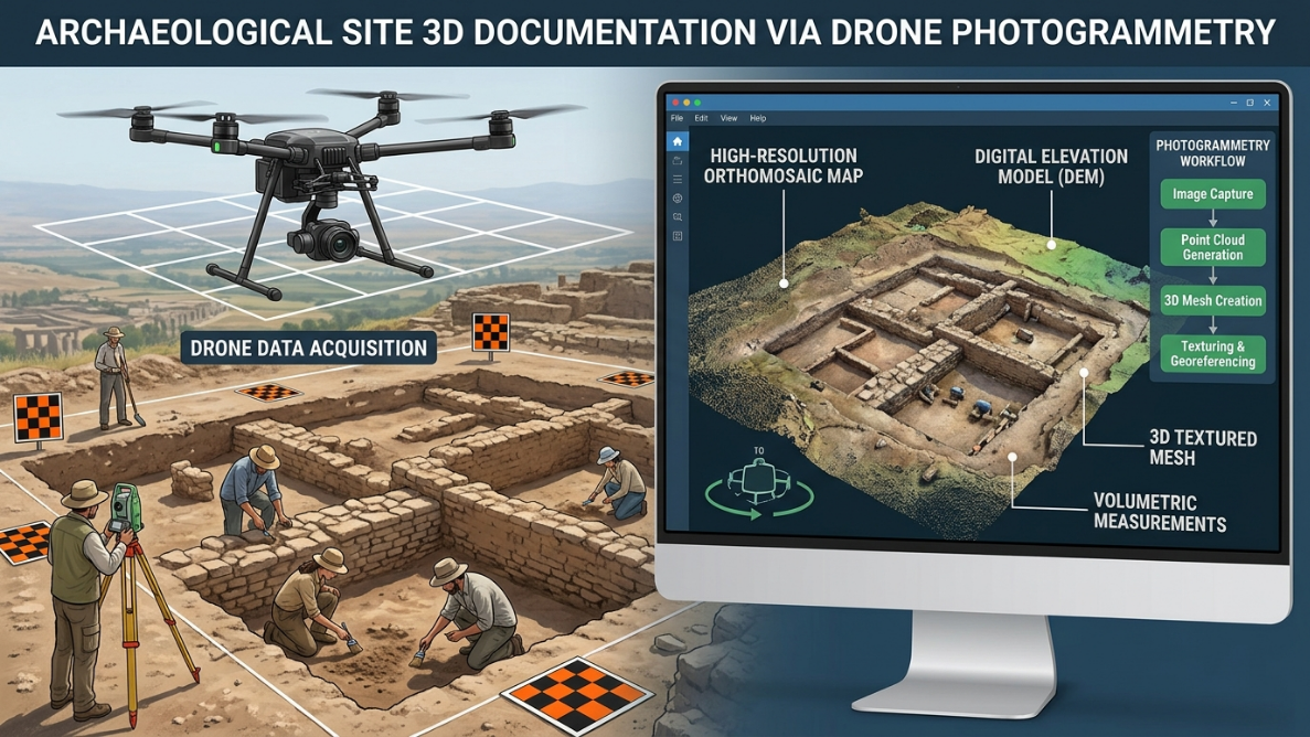
The cameras are positioned at ground level, mounted on tripods, vehicles, or handheld. They are used to document structures, buildings, archaeological objects, industrial machinery, or interiors. They allow for greater detail to be captured in more confined areas.
Underwater photogrammetry
The images are captured underwater. This technology is used in underwater archaeology, port infrastructure inspections, and marine ecosystem studies.
What is photogrammetry used for?
The applications of photogrammetry are broad and cover a wide range of industries:
Topography and Cartography
It is one of the most established applications. Photogrammetry allows the generation of topographic maps, plans of large areas, and orthophotos with georeferenced coordinates in much less time than traditional surveying with a total station.
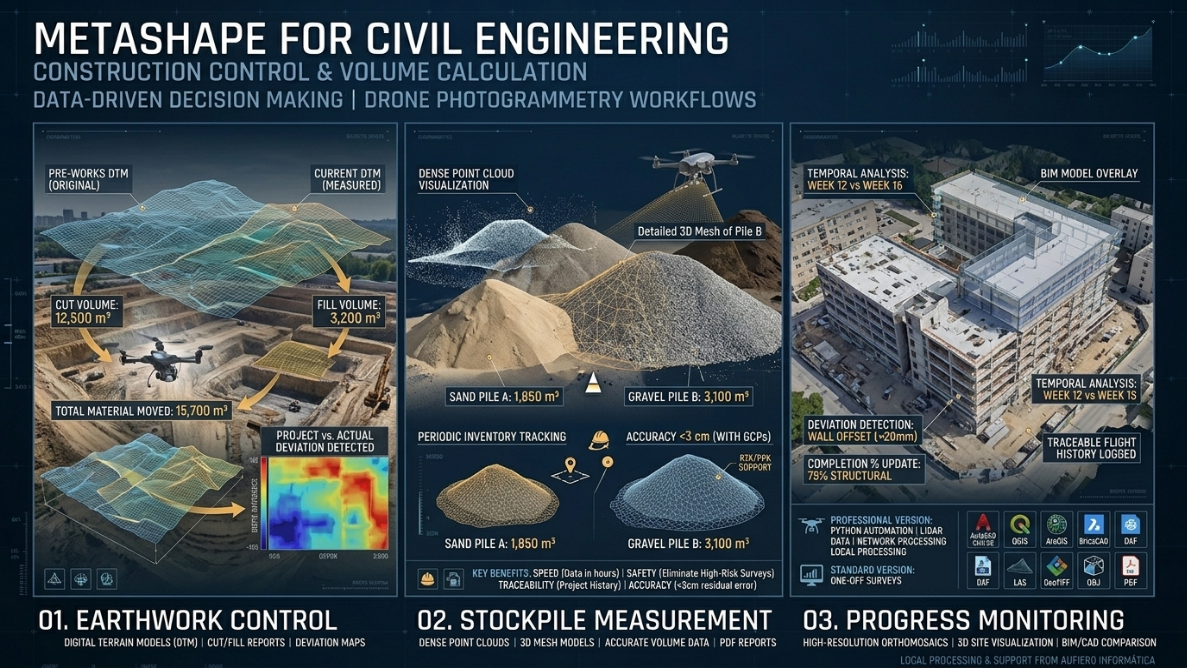
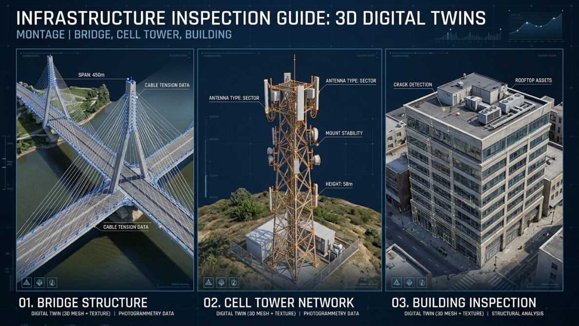
Civil engineering and construction
It is used to track the progress of works, verify that structures meet design tolerances, and inspect infrastructure such as bridges, tunnels or roads without the need for direct physical access.
Archaeology and cultural heritage
Archaeologists use photogrammetry to document sites and fragile or hard-to-reach artifacts without physically disturbing them. It allows them to create exact digital replicas of historical sites for their preservation and study.
Mining
In mining, drone photogrammetry allows for calculating stockpile volumes, monitoring extraction progress, and managing safety in hard-to-reach areas, significantly reducing risks to personnel.
Precision agriculture
Crop maps, plant condition analysis (NDVI), and terrain models are generated to plan irrigation or detect early problems in crops.
Environment and natural resources
Photogrammetry allows monitoring changes in ecosystems, detecting erosion, deforestation or coastal alterations over time with high precision.
Video games, film and virtual reality
The technique is used to create photorealistic 3D environments and objects. Capturing a real-world environment with photogrammetry and processing it for use in a video game is much faster and more accurate than modeling it manually.
Medicine and forensic sciences
It is applied in injury documentation, crime scenes, facial reconstruction and analysis of physical evidence, providing high-precision 3D models to forensic teams.
Advantages of photogrammetry over traditional methods
| Feature | Photogrammetry | Classical topography |
|---|---|---|
| Capture speed | High (especially with drones) | Low to medium |
| Area coverage | Very high | Limited |
| Access to dangerous areas | Yes (drones, remote cameras) | Limited |
| Visual detail | Very high (texture + geometry) | Just dots and lines |
| Integration with GIS/BIM/CAD | Direct | It requires more steps |
| Cost for large areas | Low | High |
What software is used for photogrammetry?
Photogrammetric processing requires specialized software capable of analyzing hundreds or thousands of images and generating the final products. One of the most widely used worldwide is Agisoft Metashape , recognized for its accuracy, versatility, and ability to handle projects of any scale.
Metashape is used by surveyors, archaeologists, engineers, geologists, researchers, and professionals in dozens of industries worldwide. It is available in Standard (general use and 3D modeling) and Professional (with advanced tools for surveying, GIS export, and automation with Python) editions.
Conclusion
Photogrammetry has gone from being a manual and expensive technique to becoming an accessible, fast, and extraordinarily accurate tool. The democratization of drones and the development of software like Agisoft Metashape have made it available to professionals in all industries.
If you are considering incorporating photogrammetry into your workflow, the first step is to have the right software and an official license that guarantees support and updates.
At Aufiero Informática , official distributors of Agisoft Metashape in Argentina, we can advise you on which edition best suits your needs and assist you from purchase to implementation.
👉 Discover the Agisoft Metashape licenses available at Aufiero Informática
Frequently Asked Questions
Does photogrammetry replace traditional surveying?
Not entirely. Photogrammetry is complementary: for extensive surveys, volumetric measurements, and documentation, it is far superior. For millimeter-precise stakeout or fine-line work, the total station remains the precision tool.
Do I need a drone for photogrammetry?
Not necessarily. For objects, structures, or interiors, a conventional camera is sufficient. Drones are necessary when the goal is to efficiently cover large areas of land.
How accurate is photogrammetry?
With good capture conditions and ground control points (GCPs), aerial photogrammetry can achieve accuracies of ±2 to 5 cm. Short-range photogrammetry can achieve millimeter accuracy.
What is Structure from Motion (SfM)?
It’s the mathematical algorithm that photogrammetric software uses to detect points of overlap between images and reconstruct the scene in 3D. It’s the basis of how software like Agisoft Metashape works.